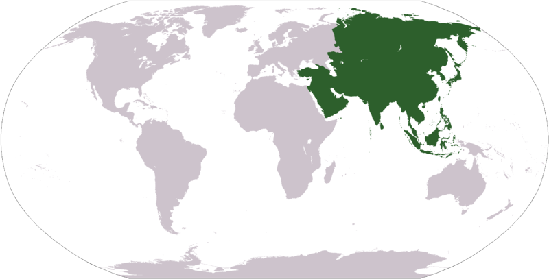
File:LocationAsia.png

Size of this preview: 800 × 407 pixels. Other resolutions: 320 × 163 pixels | 640 × 326 pixels | 1,024 × 521 pixels | 1,280 × 651 pixels | 2,759 × 1,404 pixels.
Original file (2,759 × 1,404 pixels, file size: 99 KB, MIME type: image/png)
File information
Structured data
Captions
Captions
Add a one-line explanation of what this file represents
Карта свету з выявай Азіі

|
File:LocationAsia.svg is a vector version of this file. It should be used in place of this PNG file when not inferior.
File:LocationAsia.png → File:LocationAsia.svg
For more information, see Help:SVG.
|
| DescriptionLocationAsia.png |
Deutsch: Weltkarte mit Fokus auf Asien
English: World map depicting Asia
Esperanto: Mondmapo bildiganta Azion
Español: Ubicación de Asia
Svenska: Asien |
| Date | |
| Source | own work - map adapted from PDF world map at CIA World Fact Book |
| Author | Dado |
| Public domainPublic domainfalsefalse |
This image is in the public domain because it contains materials that originally came from the United States Central Intelligence Agency's World Factbook.
Bahasa Indonesia ∙ čeština ∙ Deutsch ∙ eesti ∙ English ∙ español ∙ Esperanto ∙ français ∙ galego ∙ hrvatski ∙ italiano ∙ Nederlands ∙ norsk nynorsk ∙ polski ∙ português ∙ sicilianu ∙ slovenščina ∙ suomi ∙ Türkçe ∙ Zazaki ∙ беларуская (тарашкевіца) ∙ македонски ∙ русский ∙ српски / srpski ∙ українська ∙ ქართული ∙ বাংলা ∙ தமிழ் ∙ മലയാളം ∙ 한국어 ∙ 日本語 ∙ 中文 ∙ 中文(简体) ∙ 中文(繁體) ∙ العربية ∙ +/− |
 |
File history
Click on a date/time to view the file as it appeared at that time.
| Date/Time | Thumbnail | Dimensions | User | Comment | |
|---|---|---|---|---|---|
| current | 02:56, 13 April 2011 |  | 2,759 × 1,404 (99 KB) | Wsiegmund (talk | contribs) | Reverted to version as of 12:41, 19 January 2008; last stable version. |
| 02:37, 13 April 2011 |  | 2,759 × 1,404 (71 KB) | Gerge (talk | contribs) | Reverted to version as of 06:07, 12 April 2011 | |
| 23:10, 12 April 2011 |  | 2,759 × 1,404 (99 KB) | Green, White and Gold (talk | contribs) | Reverted to Dbachmann's version as of 14:05, 9 April 2011 | |
| 06:07, 12 April 2011 |  | 2,759 × 1,404 (71 KB) | Sigismun (talk | contribs) | Reverted to version as of 20:26, 9 April 2011 | |
| 00:59, 12 April 2011 |  | 2,759 × 1,404 (99 KB) | Green, White and Gold (talk | contribs) | Reverted to Dbachmann's version as of 14:05, 9 April 2011 | |
| 20:26, 9 April 2011 |  | 2,759 × 1,404 (71 KB) | ComtesseDeMingrelie (talk | contribs) | Reverted to version as of 18:52, 8 April 2011 | |
| 14:05, 9 April 2011 |  | 2,759 × 1,404 (99 KB) | Dbachmann (talk | contribs) | Reverted to version as of 12:13, 8 April 2011 | |
| 18:52, 8 April 2011 |  | 2,759 × 1,404 (71 KB) | ComtesseDeMingrelie (talk | contribs) | Reverted to version as of 01:06, 5 April 2011 | |
| 12:13, 8 April 2011 |  | 2,759 × 1,404 (99 KB) | Chipmunkdavis (talk | contribs) | Reverting to stable Caucasus mountain crest | |
| 01:06, 5 April 2011 |  | 2,759 × 1,404 (71 KB) | ComtesseDeMingrelie (talk | contribs) | Reverted to version as of 19:43, 4 April 2011 |
You cannot overwrite this file.
File usage on Commons
The following 12 pages use this file:
- Asia
- Church
- Churches in Europe
- Continents
- Northern Hemisphere
- Tram
- User:Achim55/SVG replacements
- User:Ch1902/Top 200 Vector version available
- Commons:Files used on the OpenStreetMap Wiki/15
- Commons:Top 200 images which have a vector version available by usage
- Category:Rail transport in Asia
- Category:Users in Asia
File usage on other wikis
The following other wikis use this file:
- Usage on als.wikipedia.org
- Usage on am.wikipedia.org
- Usage on arc.wikipedia.org
- Usage on ar.wikipedia.org
- Usage on ar.wikisource.org
- Usage on arz.wikipedia.org
- Usage on as.wikipedia.org
- Usage on avk.wikipedia.org
View more global usage of this file.
