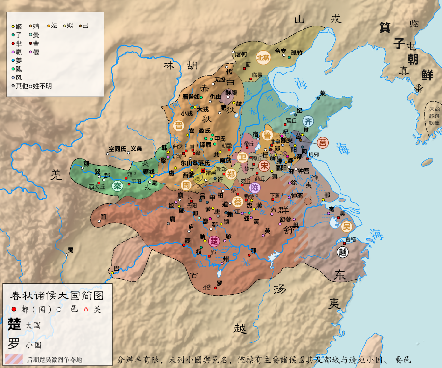
File:春秋诸侯大国简图.png
Size of this preview: 720 × 600 pixels. Other resolutions: 288 × 240 pixels | 576 × 480 pixels | 900 × 750 pixels.
Original file (900 × 750 pixels, file size: 779 KB, MIME type: image/png)
Captions
Captions
Add a one-line explanation of what this file represents
Summary
edit| Description |
中文:春秋诸侯大国简图 |
| Date | |
| Source | Own work |
| Author | 玖巧仔 |
| Other versions |


|
This map image could be re-created using vector graphics as an SVG file. This has several advantages; see Commons:Media for cleanup for more information. If an SVG form of this image is available, please upload it and afterwards replace this template with
{{vector version available|new image name}}.
It is recommended to name the SVG file “春秋诸侯大国简图.svg”—then the template Vector version available (or Vva) does not need the new image name parameter. |
Licensing
edit
I, the copyright holder of this work, hereby publish it under the following licenses:
This file is licensed under the Creative Commons Attribution-Share Alike 3.0 Unported license.
- You are free:
- to share – to copy, distribute and transmit the work
- to remix – to adapt the work
- Under the following conditions:
- attribution – You must give appropriate credit, provide a link to the license, and indicate if changes were made. You may do so in any reasonable manner, but not in any way that suggests the licensor endorses you or your use.
- share alike – If you remix, transform, or build upon the material, you must distribute your contributions under the same or compatible license as the original.

|
Permission is granted to copy, distribute and/or modify this document under the terms of the GNU Free Documentation License, Version 1.2 or any later version published by the Free Software Foundation; with no Invariant Sections, no Front-Cover Texts, and no Back-Cover Texts. A copy of the license is included in the section entitled GNU Free Documentation License. |
You may select the license of your choice.
File history
Click on a date/time to view the file as it appeared at that time.
| Date/Time | Thumbnail | Dimensions | User | Comment | |
|---|---|---|---|---|---|
| current | 07:01, 14 May 2012 | | 900 × 750 (779 KB) | 玖巧仔 (talk | contribs) | {{Location map+|China Northern Plain relief | caption=<center>夏时期全图{{注|1=根据谭其骧主编的《中国历史地图集》绘制,而有扈、涂山、三苗、防风之地实际可能更接近河南省境内的夏后氏兴祥�... |
| 12:54, 10 February 2012 |  | 900 × 750 (739 KB) | 玖巧仔 (talk | contribs) | 更 | |
| 22:58, 6 October 2011 |  | 900 × 750 (964 KB) | 玖巧仔 (talk | contribs) | 更新 | |
| 03:58, 31 August 2011 |  | 900 × 750 (1.11 MB) | 玖巧仔 (talk | contribs) | 河 | |
| 04:35, 23 August 2011 |  | 900 × 750 (1.11 MB) | 玖巧仔 (talk | contribs) | 更新 | |
| 04:14, 21 August 2011 |  | 900 × 750 (1.11 MB) | 玖巧仔 (talk | contribs) | 更新 | |
| 04:29, 16 August 2011 |  | 900 × 750 (1.1 MB) | 玖巧仔 (talk | contribs) | 更新。 | |
| 02:57, 15 August 2011 |  | 900 × 750 (1.07 MB) | 玖巧仔 (talk | contribs) | {{Information |Description ={{zh|1=春秋诸侯大国简图}} |Source ={{own}} |Author =玖巧仔 |Date =2011年 |Permission = |other_versions = }} Category:Maps of the history of China |
You cannot overwrite this file.
File usage on Commons
The following 2 pages use this file:
File usage on other wikis
The following other wikis use this file:
- Usage on ja.wikipedia.org
- Usage on ko.wikipedia.org
- Usage on ru.wikipedia.org
- Usage on uk.wikipedia.org
- Usage on vi.wikipedia.org
- Usage on www.wikidata.org
- Usage on zh-classical.wikipedia.org
- Usage on zh-yue.wikipedia.org
- Usage on zh.wikipedia.org