File:LocationLiechtenstein.png
No higher resolution available.
LocationLiechtenstein.png (250 × 115 pixels, file size: 6 KB, MIME type: image/png)
Captions
Captions
Add a one-line explanation of what this file represents
Summary
edit| Description |
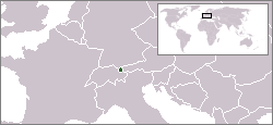
English: Location map for Liechtenstein.
Deutsch: Karte zur Lage von Liechtenstein. |
|||
| Date | ||||
| Source | Originally created for English Wikipedia by Vardion. | |||
| Author | Vardion | |||
| Other versions |
|


Licensing
edit
| |
This work has been released into the public domain by its author, Vardion, at the English Wikipedia project. This applies worldwide. In case this is not legally possible: |
| Annotations | This image is annotated: View the annotations at Commons |
File history
Click on a date/time to view the file as it appeared at that time.
| Date/Time | Thumbnail | Dimensions | User | Comment | |
|---|---|---|---|---|---|
| current | 05:59, 16 December 2004 | | 250 × 115 (6 KB) | EugeneZelenko (talk | contribs) | Location map for the Liechtenstein.<br/>Originally created for English Wikipedia by Vardion.<br/>{{PD}}<br/>Category:Country locator maps |
| 15:11, 12 December 2004 |  | 250 × 115 (6 KB) | SpeedyGonsales (talk | contribs) | Location Liechtenstein |
You cannot overwrite this file.
File usage on Commons
The following 4 pages use this file:
File usage on other wikis
The following other wikis use this file:
- Usage on als.wikipedia.org
- Usage on arc.wikipedia.org
- Usage on av.wikipedia.org
- Usage on bg.wikipedia.org
- Usage on bpy.wikipedia.org
- Usage on br.wikipedia.org
- Usage on ceb.wikipedia.org
- Usage on ckb.wikipedia.org
- Usage on cv.wikipedia.org
- Usage on de.wikipedia.org
- Usage on de.wikibooks.org
- Usage on de.wikinews.org
- Usage on de.wiktionary.org
- Usage on dsb.wikipedia.org
- Usage on el.wiktionary.org
- Usage on en.wikipedia.org
- Usage on en.wikivoyage.org
- Usage on en.wiktionary.org
- Usage on eo.wikipedia.org
- Usage on eo.wiktionary.org
- Usage on eu.wiktionary.org
- Usage on fa.wikipedia.org
- Usage on fiu-vro.wikipedia.org
- Usage on fr.wikipedia.org
- Usage on fr.wikinews.org
- Usage on fy.wikipedia.org
- Usage on gu.wikipedia.org
- Usage on he.wikivoyage.org
- Usage on hif.wikipedia.org
- Usage on ht.wikipedia.org
- Usage on ia.wikipedia.org
- Usage on id.wikipedia.org
- Usage on incubator.wikimedia.org
- Usage on it.wikivoyage.org
- Usage on ja.wikipedia.org
- Usage on jv.wikipedia.org
- Usage on ka.wiktionary.org
View more global usage of this file.